
The Clean Water Act of 1972 is often viewed as one of this country’s seminal pieces of modern environmental legislation—and rightly so. But while its impact conjures up images of finally cleaning up the almost-dead Great Lakes, or stopping Ohio’s Cuyahoga River from catching fire (as it had on numerous occasions in the past), the Act also had many other far-reaching statutes, provisions that, to this day, are still making their impact felt. One of those includes the mitigation of wetlands adversely affected by development, and the offset projects that are driven by such development. At a farm site in Monroe, North Carolina, environmental remediation specialist Wright Contracting, LLC—fulfilling just such an offset requirement—took more than 5,000 feet of what had become an unsightly drainage channel and, combining their proven expertise with some innovative, GNSS-based techniques, returned it to its former pristine condition.
MAKING THINGS WRIGHT
Established in 2008 in Lawndale, North Carolina, Wright Contracting quickly established itself as one of the region’s premier specialists in environmental restoration, with a focus on remediation of streams and wetlands. Headed up by founder Joseph Wright, the company also tackles storm water remediation projects and other urban environment projects.
“As a company, we started out small, but quickly found a niche for this type of work throughout the region,” he says. “Today we are about a dozen strong and a good part of the reason for the growth we’ve enjoyed has been the input and expertise of Stephen James who came onboard with us in 2012. His expertise—and his push to add GPS to the operation—moved us from an average company to a major player in this market.”
James, who came to Wright Contracting with more than a decade of GPS experience, has also been involved in stream restoration for about 6 years. He recommended the move to a GPS-based work environment even before joining the firm himself.
“I first talked Joe into buying a rover 2 years ago. They purchased a Sokkia GRX-1 in 2010, used it on one job and immediately fell in love with it. This year, working through Benchmark Supply, we added Topcon’s X-63 machine control system for our Volvo excavator and a HiPer II base/rover, and now GPS has become a major part of our operation.”
STREAMING GPS
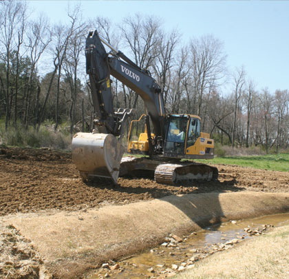
That GPS component recently paid big dividends at the Monroe stream restoration project. There, Wright and his team took a water feature that had been modified and neglected for decades and brought it back to its former state.
“Prior to us coming in, there was no vegetation—it was just a straight ditch through the middle of this farmer’s field,” says Wright. “Part of what we strive to do is restore the flood plain. We then add sinuosity back to the stream so that, instead of a straight ditch, there is some curve and flow to it as moves along—in this case, through a small valley. We also add grade control structures, pools and riffles, as well as plant vegetation, both to keep the newly-routed stream in place and to maintain a specific elevation.”
That elevation, he adds, is necessary to ensure that the water is always able to exit onto the flood plain, yet stay in that path and take a natural course. Almost every facet of what’s been done at Monroe—including layout, placement of structures, excavation, creation of slopes, and more—has been done using GPS.
“The only stakes pounded on this entire site were those used to secure the coir matting holding vegetation in place,” says Wright. “GPS eliminates all that and allows us to build it right the first time, keeping production high. I like to think of ourselves as artists using our bucket as a brush to recreate the engineer’s CAD screen.”
CASH CAB
Wright’s affinity for the new technology is shared by Bruce Hall, the firm’s excavator operator. He says there were many areas of the Monroe project in which the difference between having machine control on his Volvo 220D and the traditional way of doing things was stark.
“There’s really no comparison between the two,” he says. “In the past, before making a cut, we’d have to pull tapes, lay it out, paint our marks or pink flag them, and so on. Now I can get the same results from right in my cab. All the slopes for the stream are built into the model so the indicator lets me know if we are too low or too high. In addition, because so much of our work is under water, we sometimes can’t actually see what we are trying to grade. Before, that would have meant having a man out there with a grade rod. Instead, because the system’s sensors know where the bucket is at all times, I just look on the screen and everything I need is right there. I can even flip back and forth to different views as we move down the job.”
Wright adds that, while experience is key in stream restoration, they can now couple that know-how with what is essentially a constant look at the engineering plans. In being able to do so, he says, production skyrockets.
“Construction is all about production and making sure you have a good quality product,” he says. “With machine control the operator is able to look at the job, build it accurately, and keep production up; he no longer has to stop to look at the plans and measure. Depending on the conditions, all those benefits can translate to anywhere from a 25 to 50 percent increase in production. That’s a very nice savings.” ■
About The Author:
Larry Trojak is president of Trojak Communications, a Minnesota-based marketing communications firm. He has written for the construction, recycling, demolition, scap, and aggregate processing industries.
_________________________________________________________________________
Modern Contractor Solutions, December 2013
Did you enjoy this article?
Subscribe to the FREE Digital Edition of Modern Contractor Solutions magazine.

Back to the Future
