Users are finding varied, new ways to benefit from the growing popularity of laser scanners in the construction industry. For Blue Goose Construction (BGC), that meant augmenting traditional survey approaches in a central Florida water treatment project using a high-density laser scanning system. BGC had recently taken on a separate, larger project for which laser scanning capability was a prerequisite to the bid itself. For BGC, it proved an opportunity to evaluate further the strengths of the technology.
OFFSPRING OF A GOOSE
Formed out of the ranks of Blue Goose Growers, a Florida-based citrus grove and crop management company, the firm has established itself as a leader in a number of specialties, according to Jay Wise, manager of BGC’s GPS and technical department.
“Blue Goose Growers had crews that would do work for owners of area groves,” he says. “Those crews would be called in when a grove needed to be revamped with new drainage, irrigation, etc. That eventually led the company to take their services to the next level of general contracting, eventually evolving into a separate construction division.”
Starting as a modest operation, BGC today employs more than 120 field personnel running an arsenal of standard and specialty equipment, including an impressive offering of extreme long-reach GPS-equipped excavators.
RESTORATION INNOVATION
Largely because of its impressive portfolio and excellent reputation, BGC has been successful at landing a series of projects associated with the Upper St. John’s River Basin Project. One such project is the Fellsmere Water Management Area (FWMA), located about 25 miles west of Vero Beach, Florida, which will add an additional 10,000 acres of restored wetlands to the headwaters of the St. John’s River.
“Our part of the overall project for the FWMA includes construction of 12.5 miles of levee, and within that levee, we are building a number of structures that allow water to pass through in a controlled manner,” he says. “In the past, once we were at a point where we needed an as-built, we would call in surveyors and they would take a shot on each corner and a shot on the invert of the pipe—that was it. From that info, we would have to interpret all the data that lies in between those few shots. It’s really limited in scope.”
Wise knew there had to be a better way.
“For a different job we will be starting not far from here, we had recently purchased a Topcon GLS-2000 laser scanner,” he says. “That project, the massive South Florida Water Management District’s C-44 canal near Lake Okeechobee, came with a prerequisite that, to even bid on the job, a company must either have a scanning capability or subcontract to a firm that did. That’s the first time we’ve ever faced that, but I sense it won’t be the last—the technology is making huge inroads.”
To even bid on a nearby C-44 canal job, firms like BGC had to have a scanning capability or subcontract to a firm with that ability.
ONE-TOUCH RESULTS
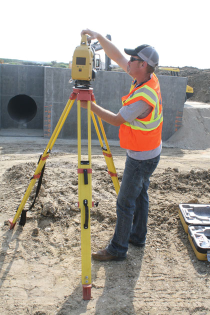
The solution to which Wise refers, a Topcon GLS-2000 Compact High-Speed 3D Laser Scanner, offers them a wealth of benefits. Capable of capturing point cloud data at a rate of up to 120,000 points per second at a distance up to 350 meters (varied and user-selectable), and offering a simple one-touch operation, Wise confirmed the instrument did not disappoint.
“We built the structure using existing control points and localization that ties us into state plane coordinates,” he says. “Then we set up the GLS-2000 and started the scanning session. In total, for the exterior of the structure, we did six different setups. We then took two final shots on the inside of the 84-inch diameter pipe and we had what we felt was everything we needed.”
Wise saved the data of the completed scan to an onboard SD card and brought it back to BGC’s offices where it was downloaded and imported into ScanMaster, Topcon’s software used for managing, cleaning, and geo-referencing the point cloud data. With the data exported to a .dwg file, they were then able to import it into AutoCAD and place the resultant image over the design drawings to get a spot-on comparison between the final product and the design.
“The big plus for us,” says Wise, “is that we now have more than five million points to look at from any given angle and from which to gather info—not just today or next year, but long down the road.”
SAFETY CONSCIOUS
Even though their scanning proficiency is admittedly still in its early stages, Wise says they’ve already had a scenario in which the technology proved its value.
“At a project not too far from this one, the customer wanted to see if an existing power line was going to meet the requirement for distance between it and a new road being built,” he says. “Specs say there must be 18 feet between the line and the highest part of the road. Normally, that would mean getting someone in a man lift to get close, or using a grade rod to determine the height; however, because we had already done a preconstruction scan, I told him I was pretty sure I already had what they needed. I opened up the scan and there it was. I selected a point on the power line, saw that it was 20 feet over the crown of the road and the issue was settled. In this case alone, we not only got the results we needed in a much faster and safer way, we also saved on manpower and equipment use.”
He adds that they foresee scanning playing an important role in other areas, such as volume calculations, elevation verifications, and more. “This is an excellent tool to have; it’s the technology that keeps on giving.” ■
For More Information: Blue Goose Construction provides a variety of services to the commercial, agricultural, and governmental markets. For more information, visit www.bluegoosegrowers.com.
_________________________________________________________________________
Modern Contractor Solutions, July 2015
Did you enjoy this article?
Subscribe to the FREE Digital Edition of Modern Contractor Solutions magazine.